Overview
Evapotranspiration (ET) is critical for field-level water management and irrigation scheduling, as well as assessing regional water budgets, water productivity, and drought.
Crop Water Use
ET is the sum of evaporation from the soil surface and transpiration from plants (Figure 1).
To illustrate transpiration, imagine sealing a clear plastic bag around a plant excluding the soil(Figure 2). If you return a day later, there will be a thin layer of moisture condensed along the inside of the bag. This moisture is water transpired by the plant, which is essential for supporting photosynthesis and growth.
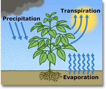
Figure 1: ET as part of the water cycle. Image Source: USGS

Figure 2: Hypothetical experiment to measure transpiration
To measure ET in a potted plant, we can simply weigh the pot at the beginning and end of a 24-hour period. But obviously, this will not work in the field where there are thousands of plants, or across a county with many fields. So, how do we accurately measure ET in a field, or across a watershed?
Measuring Evapotranspiration
SmartFlux Technology
ET can be measured using SmartFlux Eddy Covariance Systems developed by LI-COR Biosciences. These systems provide advanced tower and sensor configurations that can directly measure ET at field-scale. The Parallel 41 Flux Network is a geographic collection of such flux systems deployed for continuously measuring ET and photosynthetic carbon assimilation every half-hour, across a range of different crop types and climate conditions in the U.S. Integrated daily values are reported here.
Parallel 41 Network
The name Parallel 41 comes from latitude line 41 north, which runs east to west across the central United States. Parallel 41 traverses a region of significant food production with a gradient in geography and climate. Recently, additional towers were added along a gradient running south to north from northern New Mexico to west-central Wyoming in the Colorado River Basin.
Satellite Remote Sensing
Satellite-based remote sensing can provide ET measurements across hundreds of miles using satellite data and mathematical models to produce physical-based ET estimates at 30-meter (~100ft) resolution. Daily ET calculations across many countries, including the United States, Brazil, India, and the Middle East and North Africa region, are freely available through the Global Daily Evapotranspiration (GLoDET)website, which is a partner site with Parallel 41.
Integrated Approach
Combining results from the Parallel 41 Flux Network with GLODET datasets provides a powerful synergy. The goal is to use satellite remote sensing measurements anchored with ground-truth results from flux towers, to provide reliable daily crop and ecosystem water use (ET) measurements over large areas with a wide range of geographies, ecosystems, crop types, and climates (Figure 3).
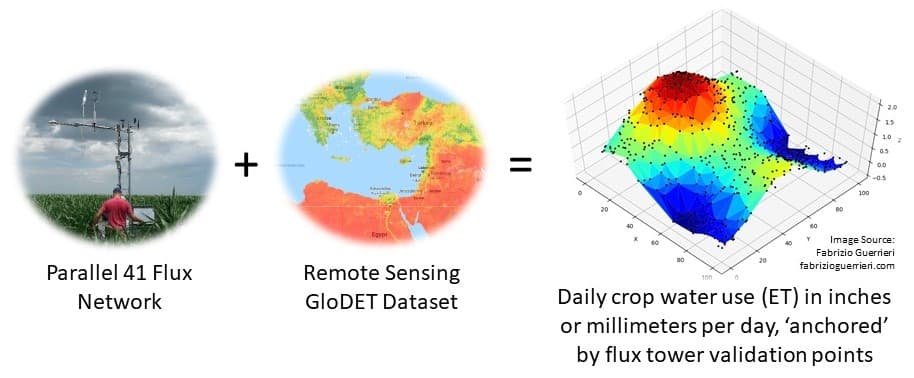
Figure 3: Strategy for Measuring ET at large spatial scales
Datasets Available
Core ET Data
The Parallel 41 website provides daily summaries of continuously measured and quality-controlled ET, in inches or millimeters per day. It also includes daily summaries of reference ET (ETr), daily crop coefficients (Kc), and cumulative measured ET during the growing season.
Extended Data
Additional information measured and recorded by the flux towers is available upon request. These additional data are useful for tracking climate variability and trends over time, and to support water use planning and policy development. The real-time datasets provided by the updated equipment suites in this network can be used to manage water on a day-to-day basis, and to study the impacts of climate and management practices on crop yields and water availability across the region.
Citation Instructions
When using Parallel 41 datasets in your work, please provide the following citation:
Daugherty Water for Food Global Institute at the University of Nebraska. (Year). Parallel 41 Flux Network. Lincoln, NE, USA. <parallel41.nebraska.edu>.
Development Team
The following people were key leaders and developers for the overall Parallel 41 program. Additional partners are gratefully acknowledged in the Partners and Acknowledgments sections below.

Christopher Neale, Ph.D.
Director of Research, Daugherty Water for Food Global Institute at the University of Nebraska

George Burba, Ph.D.
Science & Strategy Fellow, LI-COR Biosciences; Global Fellow, Daugherty Water for Food Global Institute at the University of Nebraska

Dayle McDermitt, Ph.D.
Adjunct Professor, Agronomy and Horticulture, Faculty Fellow, Daugherty Water for Food Global Institute at the University of Nebraska

Ashish Masih, M.S.
Research Engineer, Daugherty Water for Food Global Institute at the University of Nebraska

Ahmadreza Pourghodrat, M.S.
Software developer, Daugherty Water for Food Global Institute at the University of Nebraska

Regiane Carvalho, Ph.D.
Postdoctoral Researcher, Daugherty Water for Food Global Institute at the University of Nebraska
Partners
The Daugherty Water for Food Global Institute at the University of Nebraska (DWFI) collaborates with numerous partners, including government agencies, private industry and academic institutions, to obtain the vital resources and expertise needed to implement and maintain the Parallel 41 Flux Network.
USDA-ARS IOWA
Site Leader
- John Prueger
Sites
Eastern Nebraska Research, Extension and Education Center (ENREEC)
Site Leader
- Andy Suyker
Sites
Upper Republican Natural Resources District (URNRD)
Site Leader
- Ashish Masih
Sites
Upper Colorado River Commission
Site Leaders
- Ashish Masih
- Regiane De Carvalho Bispo
Sites
Acknowledgments
We gratefully acknowledge funding support from the Upper Colorado River Commission, the Irrigation Innovation Consortium, IICE, and USDA; the donation of several eddy covariance towers Dr. Val Kovalskyy of the Climate Corporation; and technical support and training from LI-COR Biosciences; and the cooperation of Mr. Nate Jenkins and the Upper Republican Natural Resources District, Mr. Roric Paulman of Paulman Farms, and Mr. Ted Tietjen.